

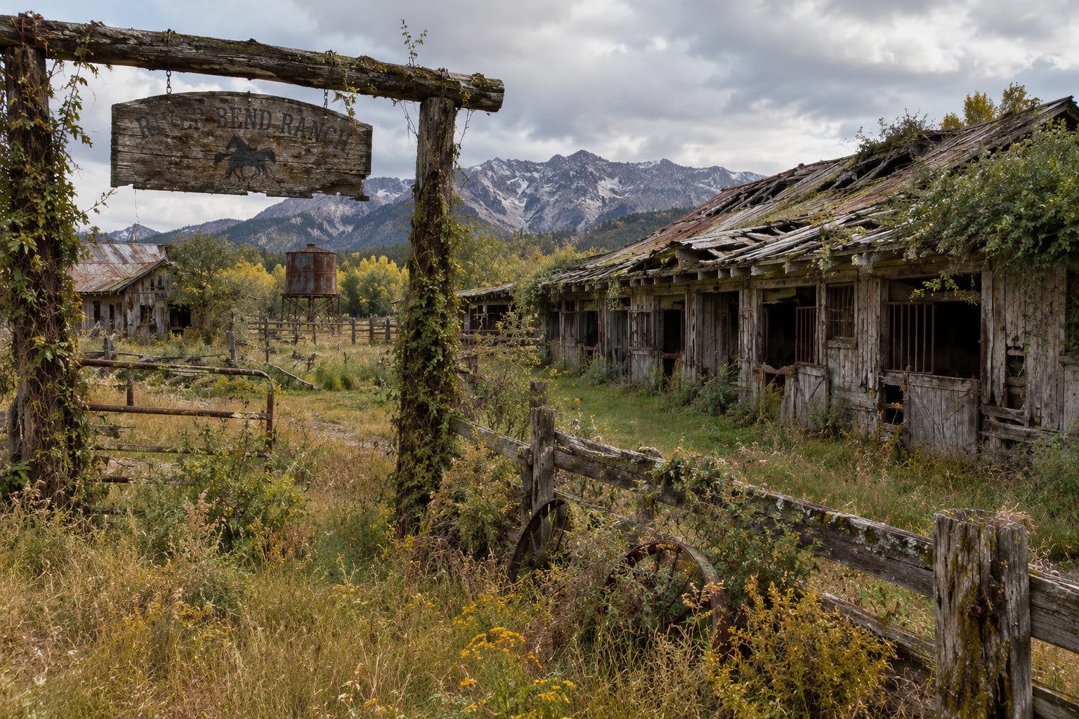
As we were driving past the remains of River Bend Ranch, we all got a heavy stomach. It’s sad to see what once were the stables and the ranch house, now all in shambles and partly overgrown.
“The Jacksons are still in the area,” Bob said. “They now live in a three room flat in town.”
We all wanted to know what had happened at the ranch, but Bob filled us in.
“Their could no longer afford their insurance. Then we had a the storm of the century. Their roof blew off. They simply couldn’t foot the bill for the repairs.”
We wondered why their insurance was so much more expensive then ours, but Bob explained that as well.
“We’re lucky to be far enough from the rugged parts of the Foothills,” he said. “Over there, fire risk models predict them to be at ‘extreme’ fire risk.”
We still had a hard time understanding what he was saying, though. Yes, this is a dry region and wildfires do occur naturally from time to time. But we couldn’t remember any particular one that was larger or less controllable, be it near us or in the rugged Foothills.
In recent years, insurance policies have gotten more and more specific to the customer, and also to the subject. One area where this has become most obvious is wildfire-ridden California. A recent report from Stanford has analyzed trends in home insurance policy prices. Owing to actions by state and federal administrations and the Federal Reserve, inflation has not been mild in California over the past five years: it amounts to an approximate twenty-five percent increase over that period. Yet home insurance policy prices have gone up more than that in many counties. In fact, only a handful of counties can be found where prices surged less than or equal to inflation. Several counties have actually witnessed over 100% jumps over that same period, which amounts to four times inflation, or more.
Many factors contribute to how insurance prices are determined. In the case of California real estate, two forces were at play that acted in opposite directions. On the one hand, regulation (California’s Proposal 103 from 1988) required insurers to base prices on long-window, backward looking moving averages – prior to approval by the California Department of Insurance (CDI). On the other hand, the intense wildfire seasons of 2017 and 2018, which included wildfires that destroyed entire neighborhoods, made insurers face record losses. As a result, some insurers pulled out altogether, while others stayed, while massively increasing policy prices. The CDI must have found itself between a rock and a hard place, having to choose between approving the high rates, or seeing insurers leave the area altogether. A similar scenario has played out in Colorado.
Given the sheer amount of destroyed properties, it is very understandable that insurers would want more accurate methods to assess risk. In fact, insurance companies became very interested in the potential to use forward-looking models. Their reasoning goes as follows: if they could use accurate forecasts of wildfire risk, their premiums could accurately account for future risk of wildfires at the insured property. However, forecasting the future is a pretty difficult task. It is even more so for a phenomenon as complex as wildfires. Accurate forecasts of wildfires would need a perfect understanding – and real-time data – of weather patterns and their impact, but also of forest management practices, the state of repair, or disrepair, of power lines and arsonists’ state of mind, since all of those were proven to have caused wildfires over the past few years.
Regulators and legislators could have walked different paths, but in both California and Colorado, they decided to go along and grant insurers their wish of being able to use forward-looking models, subject to restrictions. In 2022, California updated Title 10 of its Code of Regulations (CCR) to include a new paragraph (2644.9) entitled “Consideration of Mitigation Factors; Wildfire Risk Models.” Colorado went a step further than that, by enacting a new State Statute (Colo. Rev. Stat. § 10-4-124).
California’s regulation states that insurers can only use forward-looking models for ratemaking if insurers commit to increased writing of policies in designated wildfire-distressed areas and if the models incorporate the best available scientific information on mitigation at the property, community, and landscape scales. The path California and Colorado authorities decided to walk, is to fulfil insurers’ wishes to use forecasts of wildfires rather than historic data, subject to the condition that they take mitigation efforts into account. Instead of having entire towns or counties de facto uninsurable, these new laws and regulations should lead to the outcome that many properties can still be insured, most of all so if the owner can demonstrate that mitigation measures have been taken.
Although the intention of the new codes and regulations seems to have been to make more properties insurable, the result is that insurers in those states are now required to use highly granular models that provide forecasts and account for mitigation with specificity to the individual property. Unfortunately, the statutes do not say how such models need to be built. As a result, insurers may use any kind of model that fits the very vague bill. One such model was brought to our attention by an undisclosed source. We can only state that the model was neither suitable to forecast time series, nor to account for geospatial data. The model we saw could perfectly end up predicting very different wildfire risk scores for neighboring properties, without there being any physical explanation for the difference. One can compare this to two persons with similar backgrounds and behaviours getting very different credit scores and nobody would be able to come up with a better explanation than “the computer said so.” Would anyone want to have their insurance premium increased drastically because a model artifact predicts a wildfire risk much higher than it should be?
An even deeper question that needs to be asked, is why forecasting models would need to be used in the first place. It appears that insurers, regulators and legislators are all bought into the theory that “wildfires are getting more extreme because of climate change.” If wildfires are indeed become more frequent and more extreme, then historical data should not be used to assess risk. However, in spite of the pump and circumstance in the mainstream media to that tone, some recent scientific publications on wildfires in the Western United States conclude that they are not becoming more frequent, nor more extreme.
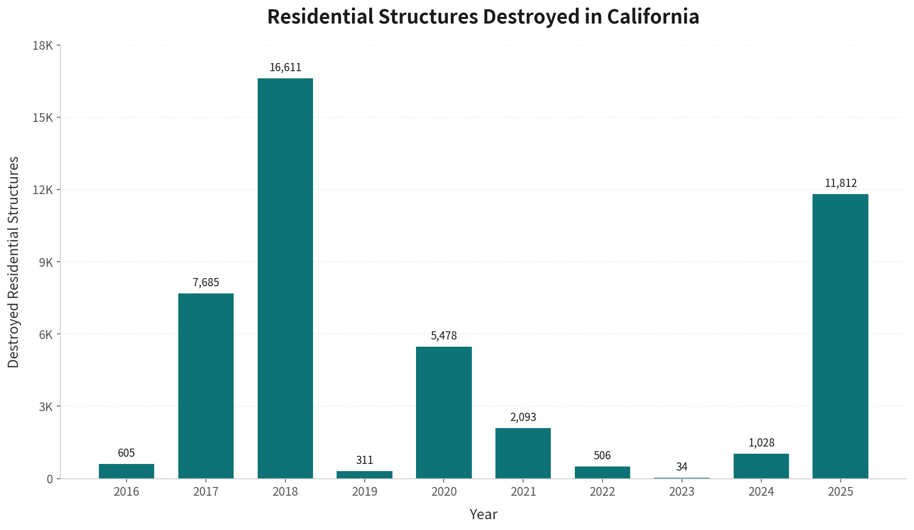
It is true that a record number of residential structures was destroyed in California in the 2017-2018 wildfires, with 2025 being a solid second. In the 2017-218 season, the most destructive fires were the Mendocino complex (2018, ~459,000 acres), Thomas (2017, ~282,000 acres) and Camp fires (2018, ~153,000 acres, 85 deaths, nearly 19,000 structures destroyed). Official results of investigations into their root causes are meanwhile known. The Thomas fire was caused by two of Southern California Electric’s power lines that accidentally touched each other and dropped molten metal onto the vegetation (also known as electric arcing). The Mendocino complex was traced back to sparks that were generated when driving a metal pole into to ground. The Camp fire was caused by disrepair of Pacific Gas and Electric’s power lines.
Jumping forward to 2025, we all remember the large amount of prime real estate being destroyed in Los Angeles, the Pacific Palisades and Malibu. However, it is not as common knowledge that an arsonist has been arrested for starting one of those fires, or that a nearby LA Department of Public Works reservoir was sitting entirely dry due to disrepair, which made containment of the fire much more tedious than it otherwise would have been:

Armed with these facts, it is hard to continue advocating for “forward-looking” models that will “more accurately predict local wildfire risk in times of climate change,” since none of those models accounts for accidental electric arc generation, disrepair in power lines, accidental sparking, arson, or temporary absence of mitigation resources. Of all the fires mentioned, exact zero could have been forecast with higher accuracy if such models had been used.
One should strongly question if regulators and legislators are walking the right path by mandating the use of highly granular, forward-looking models. Maybe it would be better to acknowledge that we have had a very unfortunate confluence of highly unlikely events, and to get insurers back to the table for day-to-day business by not imposing the burthen of such events directly on them. Instead, we could take a path similar to the Federal Deposit Insurance Company, which guarantees funds of bank accounts in case of bank failure. Build a statewide disaster insurance fund, which can be tapped in case of a highly unlikely catastrophe.
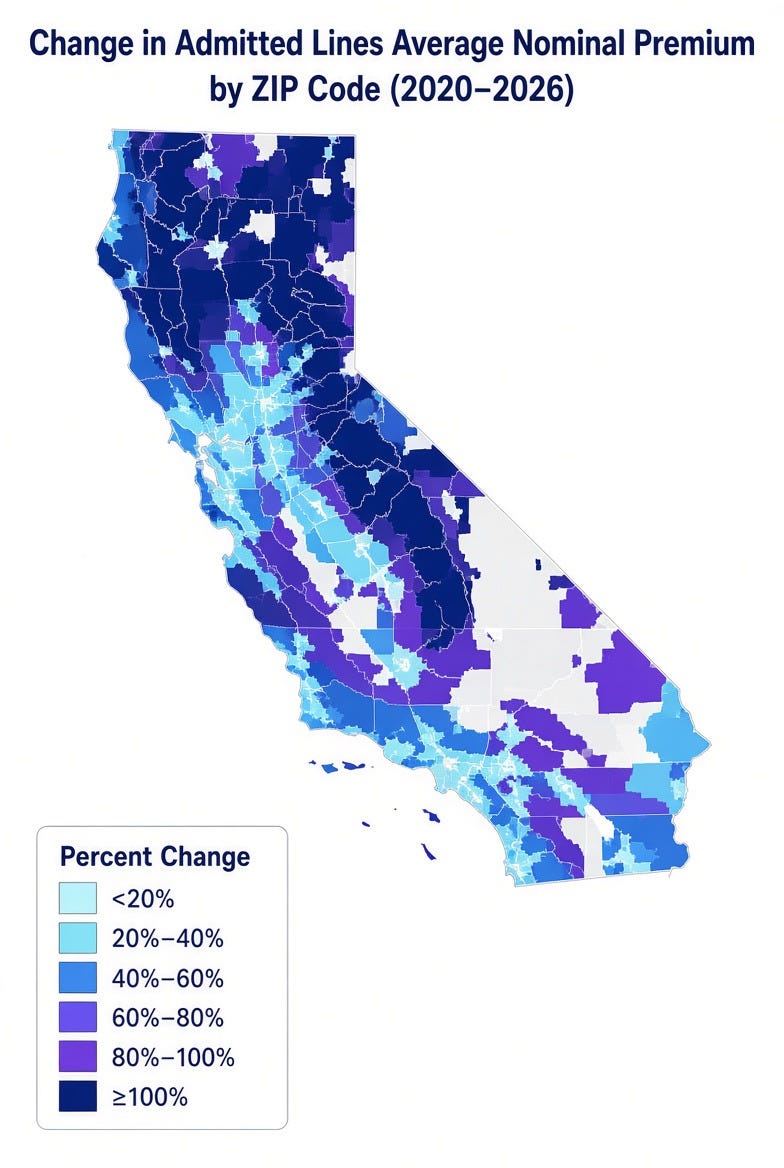
In absence of such measures, we can only observe that insurance prices are going through the roof, most of all so in more rural and more remote areas. It may seem odd that most of the high-premium — and typically high-wildfire-risk — areas in California tend to have substantially lower average home values than low-premium urban or coastal areas. The bulk of the state’s total residential property value is concentrated in lower-risk big-city and dense suburban locations. Given this distribution, one would expect insurers to be able to generate enough float from low-risk areas to not be too much affected by individual write-offs in higher-risk areas.
Maybe insurers are acting alone in their continuing drive towards individualization of risk estimates and policies. However, the trend towards customization and the use of “forward-looking models” also happens to fit into a bigger picture, in which insurance seems to be playing a convenient – and possibly unsolicited – part. California and Colorado are not outliers on a global basis. In Canada, mainstream media report that climate change is “finally being felt in our wallets” due to skyrocketing insurance premiums and in Australia, some estimates state that one in twenty-five properties may become uninsurable by 2035 due to “climate risk.” Of course, “climate risk” only exists in theoretical, forward-looking climate models that fail to predict the present, but somehow need to be believed as gospel for what will happen in the future.
A narrative based on hypothetical concoctions can make millions of properties uninsurable, if we allow climate models to be used. It is possible that insurers are the ones driving this. One can not help but notice, though, that it would be very convenient to make rural homes uninsurable if, say, one wanted to concentrate populations in fifteen-minute cities. For the uninitiated, those are cities subdivided into zones in which no walk longer then fifteen minutes is necessary to get all of life’s necessities, which would greatly reduce their “carbon footprint” … as would reaching their targets of absolute zero meat and dairy consumption. Fortunately, we are not yet there and let’s hope we never will. A good step to avoid such a scenario is to stop the use of “climate risk” models that bear no semblance to reality anyway.
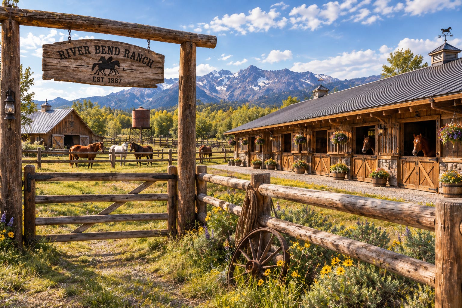
The Jacksons went through a rough patch when they had to abandon their ranch. Fortunately, though, there is still enough money around in the area. River Bend was acquired by Frank, the second-oldest son of Ben at Brunch Creek, who wanted to start his own operation. As to the insurance: Vance is still our representative. He says he’s “taking care of the insurance issue.” We trust it will all work out. As Ben put it: “a lot of water will have to flow through Brunch Creek before ranching ceases to exist.” By that he sure means a long time, because there usually isn’t that much water in Brunch Creek in the first place.